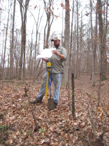
What is a forensic boundary survey?
Forensics has to do with the court of law; therefore, a forensic survey is one which will stand up to the scrutiny of law. Typically when there is a litigious situation a forensic boundary survey is required. Often there will be other surveyors who will try and dispute the outcome; therefore, everything must be done “by the book”. For instance, a typical waiver on a survey might read “This survey was prepared without the benefit of a title search. All matters pertaining to title are excepted.” You should never see that statement on a forensic survey because a title search back to the originating deed should have been performed before the first bit of field evidence has been collected. The amount of evidence collected in the field is also different. If the tract of land is within a plated subdivision the entire block lines are run out at a minimum and sometimes the boundary of the entire subdivision is reestablished to make sure that monuments found are the original survey monuments and not an erroneous retracement monument. In Georgia, if the property in question is not in a plated subdivision then it has junior and senior deed rights. For example, a 212 acre farm tract that has been divided and given to the children as wedding gifts over time. The first child to get married would have senior deed rights. Then the second child would have junior deed rights and the third junior to the second and so on. This comes into play when the remaining tract which was supposed to be a quarter of the original 212 acres only comes out to be 50 acres when it should have been 53 acres. There is no state law that states this but it is a matter of case law that has formed these rules. Riley vs. Griffin is an often cited case that sets the precedent that the original surveyor’s monuments shall hold over distances and direction. Therefore, even if the original surveyor has made an error in setting property cornes the monumentation shall control. That premise puts a lot of pressure on the surveyor to identify what kind of pins were used at the time the original surveyor laid out the property lines. The surveyor also has to identify their techniques and methods wheather the original surveyor was laying out Virginia Highlands in the 1910s or a recent subdivision like Horseshoe Bend in the 1980’s. A good forensic surveyor knows the history of the area along with the surveyors before him, how accurate their work was and who they were working for.
Here at Georgia Land Surveying we put ourselves out there as experts when it comes to reestablishing lost boundary lines and have had to defend that position. In doing so, we see more problematic jobs than most. Not all boundary issues can be solved by surveying. An attorney may need to get involved wheather it is to advise the client or litigate a case.